
Coastal Smart Growth Home: Element 2
ELEMENT 2:
Take advantage of compact community design that enhances, preserves, and provides access to waterfront resources
Smart Growth Principle
Compact design of buildings and neighborhoods can help communities use land more efficiently, which has several advantages. Well-designed, appropriately scaled compact development accommodates more uses on less land, which preserves natural areas and requires less funding for building and maintaining infrastructure. Compact communities can provide a wide range of housing choices, from single-family homes to apartments and townhouses, allowing people of different incomes and at different stages of life to live in the same neighborhood. As mentioned in Element 1, when a variety of uses are close together, people are more likely to walk, public places are livelier, and a civic identity develops more readily than in a conventionally planned development. Compact communities also help achieve the population density needed to support more transportation choices, including public transit. The form and density of compact design will vary with its context, with urbanized settings being generally appropriate for more units per acre than rural ones.
Coastal and Waterfront Context
Coastal and waterfront communities have a natural boundary-the water-that makes efficient land use critical. Not only is development physically limited within this boundary, but proximity to the water is often of highest value and at greatest risk from natural hazards, requiring an approach to community and building design that provides high structural integrity and the greatest benefit on the least amount of land. Compact community design accommodates increased development in waterfront districts through higher densities and narrower streets. Through smaller building footprints for new construction, reuse of existing buildings, and creative solutions to parking (discussed in Element 8), compact building design can leave undeveloped land to absorb rainwater, thereby reducing the overall level of impervious surface in the watershed. Together, compact community and building design techniques reduce runoff, flooding, and stormwater drainage needs, contributing to better watershed health. For waterfront communities dependent on the health and beauty of neighboring waters, these outcomes are vital.
Tools & Techniques
Since compact design will still include impervious surfaces, communities are well-served by incorporating site-level green infrastructure/low impact development (LID) practices to manage stormwater runoff. Many attractive techniques are available, including rain gardens, tree boxes, and green roofs. Combining these site-specific approaches with the preservation and restoration of larger interconnected natural areas (a green infrastructure network at the community and regional scale) can protect local aquatic resources and help communities be more resilient to the impacts of natural hazards and climate change.
At the confluence of the Willamette and Columbia Rivers, Portland, Oregon, is an excellent example of a waterfront community that has made the connection between how it grows and the health of its rivers. In addition to its many efforts to build compactly within existing neighborhoods, Portland has implemented green infrastructure policies that support compact design. Those policies include incentives, such as stormwater fee discounts and higher allowed density, for new construction projects that include green roofs. Portland has combined these policies with a comprehensive Metropolitan Greenspaces Program that provides recreational opportunities while also protecting the city's water quality, floodplains, and fish and wildlife habitat.
Waterfront communities are linked to the water by docks, piers, and boardwalks. Applying compact community design principles to these uses can improve both function and aesthetics. The proliferation of individual docks shades and fragments aquatic habitats and impairs the view of the water. Docks also can crowd navigation channels, making it difficult for large and small watercraft to maneuver. Compact designs, including shared access points and community docks, can reduce visual and habitat impacts, navigational hazards, and conflicts among water-dependent uses. These compact designs also can create attractive community spaces. For example, on Skidaway Island near Savannah, Georgia, the Landings community built two community marinas instead of allowing private docks. This compact approach protects marsh habitat, preserves scenic vistas, and lets residents enjoy the island's shorelines free of the crowding from multiple docks. Since then, the state has increasingly seen developers placing deed restrictions on waterfront lots to prevent the building of individual docks in favor of promoting community-based approaches.
Waterfront views are an eagerly sought amenity; communities can protect them by using compact design approaches such as a "wedding cake" approach. Here, the area with the highest development density is a short distance inland at a higher elevation. Building heights gradually decrease as development approaches the waterfront. Putting denser development on higher land with taller buildings protects water views for all buildings as they step down in height to the water. This preserves visual access to the water across the community, creating a compact neighborhood that complements surrounding uses, including the waterfront itself.
Compact development can capitalize on the natural advantages of the waterfront, provide attractive communities by the water, protect valued assets, and improve the overall quality of life. When applied at both the building- and community-level, compact design can make better use of the land at the water's edge, as well as the water bordering it.
| Key Action Options | Policies, Tools, and Techniques for Implementation |
|---|---|
| Offer incentives that encourage local communities to increase density |
|
| Create walkable communities and emphasize pedestrian access to and along the waterfront |
|
| Match building scale to street |
|
| Maintain and increase viewshed for waterfront area |
|
| Integrate hazard mitigation into local comprehensive and capital planning and regulations |
|
| Encourage green infrastructure approaches at the site, community, and regional scales to increase resilience to natural hazards (including climate change impacts) and better manage stormwater runoff |
|
Case Study: Barnstable, Massachusetts
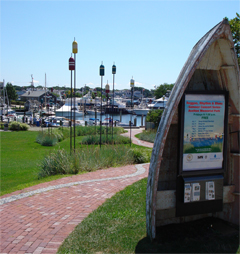
A public walkway connects downtown Hyannis, Massachusetts, with the waterfront. Courtesy: Town of Barnstable
Located on Cape Cod, the town of Barnstable has been experiencing tremendous growth. In particular, Hyannis, one of the town's seven villages, was seeing low-density growth at its edges while its downtown emptied. This pattern strained the town's infrastructure and diminished its historic character.
In response, Hyannis developed a strategy that encourages growth in the urban center, which is served by existing sewer and water lines. The strategy includes mixed-use zoning and design guidelines, expedited permitting for downtown development, incentives to shift development from outlying areas to downtown, and improved connections to the waterfront. The town also purchased land to protect drinking-water aquifers and other important natural areas.
The result is a renaissance for Hyannis's downtown. As of 2007, 93 new residential units and 22,000 square feet of commercial space had been created since the initiative began, along with approximately 342 new jobs and $25 million in private investment. Improvements continue, including construction of a harbor-front visitor's center and additional segments for the town's planned harbor walk.
