
Coastal Smart Growth Home: Element 5
ELEMENT 5:
Foster distinctive, attractive communities with a strong sense of place that capitalizes on the waterfront's heritage
Smart Growth Principle
Vibrant streets and attractive public spaces are hallmarks of healthy communities. Distinctive features such as tree-lined boulevards, historic buildings, or rows of shops and cafes make neighborhoods and downtown centers places where people want to be. Old buildings lend themselves to reuse as housing, businesses, and cultural centers; new building designs can blend with the character of surrounding structures and the environment. Smart growth approaches reflect the varied interests of community residents, creating a more cohesive community fabric that helps maintain economic vitality.
Coastal and Waterfront Context
Many of the techniques that inland communities use to ensure that new growth and development enhance the character of a place also apply to communities along the water. Waterfront and coastal communities are defined by the sights, sounds, and smells of the water; the activity on the docks or wharves; and the opportunity to boat, swim, and fish nearby. While historically these communities took advantage of their location for industries such as shipbuilding, fish processing, and warehousing, over time many of the buildings and docks that supported those activities have fallen into disrepair. But communities can adapt neglected historic buildings and structures for reuse. Protected and restored lighthouses, harbors, and public piers can affirm historical connections and draw both visitors and residents. These features not only represent physical assets that illustrate the community's sense of place, but they can also be the center point for redevelopment that strengthens the local economy.
Tools & Techniques
Regional and global economic changes may mean that many small-scale fishing, shipping, and other traditional ventures are now less viable. Efforts to maintain a working waterfront often require thoughtful intervention and land use management by local government. Many communities envision a working waterfront as part of their revitalization efforts and adopt policies to support it. For example, Newburyport, Massachusetts, uses a number of strategies to create a vibrant waterfront. The city initiated an urban renewal project in the 1970s that documented historic buildings and eventually led to the establishment of a historic district. Newburyport protected water-dependent uses, including boatyards and marinas, from encroachment, created a mixed-use district along the Merrimack River, and adopted design and zoning guidelines for new development to protect the town's historic character. The city also developed a strategy for streets and public paths to protect views and access to the water and extended a harbor walk connecting neighborhoods to the downtown and its waterfront parks. The waterfront is now a central gathering place for residents and tourists alike and is in easy walking distance of restaurants, art galleries, and other amenities.
Coastal and waterfront communities can capitalize on their location and strengthen their sense of place by visually and physically connecting (or reconnecting) their streets, buildings, and public spaces with the water. The waterfront community of St. Andrews, Florida, used its traditional working waterfront and historic structures along the St. Andrews Bay as the focal point for community revitalization. Tourism and charter fishing flourished in St. Andrews until the 1970s, when the charter boats moved to neighboring beach communities, and the historic community fell into decline. Through a community-based visioning process, residents identified existing historic and cultural resources as a revitalization priority. The resulting redevelopment plan focused on strengthening these assets through targeted investments in the working waterfront and historic district, including a wayfinding signage program.
Chattanooga, Tennessee, also recognized the opportunity that existed in its neglected waterfront along the Tennessee River and made it a centerpiece of its revitalization efforts. Faced with extensive air pollution and a weakening economy, Chattanooga initiated a public visioning process in 1984 and created a plan to turn the city around. The plan helped Chattanooga transform its riverfront into a focal point for residents and tourists through the addition of an aquarium, art museum, public art, picnic areas, natural greenways to protect creek corridors leading to the river, and pedestrian bridges to facilitate access. The result is evident not only in Chattanooga's reclaimed relationship with the river, but also in the revitalization of the broader community that these waterfront efforts inspired.
In new coastal or waterfront communities, pedestrian-scaled streets, well-designed buildings, and inviting public spaces can be connected with the water to create great places. In established communities, redevelopment efforts can incorporate buildings, docks, and other structures historically connected to the working waterfront, capitalizing on the rich heritage the waterfront provides.
| Key Action Options | Policies, Tools, and Techniques for Implementation |
|---|---|
Create an understanding of the community's assets |
|
Create a community vision for the future |
|
Incorporate the community vision into policies and codes for new development as well as redevelopment projects |
|
Incorporate historic and cultural structures in development projects, including working waterfront features such as buildings, docks, and piers. |
|
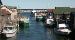
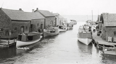
Revitalization of the Fishtown docks helped Leland, Michigan, capitalize on its heritage and history despite the decline of its traditional fisheries based economy. Courtesy: Rick Lahmann (above) and Leeland Historical Society (below)
Case Study: Leland, Michigan
Leland, Michigan, turned the challenge of a declining commercial fishery into an economic opportunity by focusing revitalization efforts on its historic and natural resources fronting the Leland River and Lake Michigan. Leland identified the fishing complex known as "Fishtown,"with its weathered fishing shanties, smokehouses, and docks, as a key element to preserve in maintaining the city's maritime heritage. Listed on the National Register of Historic Places, the preserved and renovated structures of Fishtown now provide visitors with an opportunity to learn about the Great Lakes' maritime tradition and enjoy recreational activities on Lake Michigan and Lake Leelanau. Fishtown has helped Leland, with its walkable downtown and easy access to the water, capitalize on its heritage and history despite the decline of its traditional fisheries-based economy.
