
Coastal Smart Growth Home: Case Studies
The following case studies demonstrate the application of Coastal & Waterfront Smart Growth elements:
ELEMENT 1:
Mix land uses, including water-dependent uses
Portland, Maine
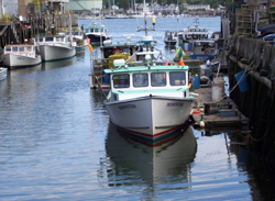
In Portland, Maine, compatible uses, such as offices, are located above commercial fishing businesses. Courtesy: Bill Needleman
Portland, Maine, located on Casco Bay, began its waterfront planning effort by identifying a range of land uses appropriate for its commercial harbor (water-dependent, marine-related, and compatible non-marine) and then developing zoning approaches that allowed these uses to be mixed together. The community found that adopting a mixed-use zone that allows compatible non-marine uses to be located above and in certain areas along side water-dependent uses was more successful (and flexible) than the previous zoning designation, which restricted the waterfront area solely to water-dependent uses. This zoning change allowed pier and wharf owners to fill vacant properties and generate income by leasing second-floor space and other commercial space, which helped pay for the high costs of maintaining commercial marine infrastructure. For instance, Portland's Union Wharf rents dock-level space to commercial fishers and harbor support industries, while the upper-level space is rented to law offices andother businesses. The rent from the upstairs tenants subsidizes the water-based activities on the dock. The mixed-use overlay also allows development of appropriate "transitional" uses, such as research facilities, that can buffer marine industries (such as shipping or processing facilities) from nearby residential or commercial uses and provide jobs within walking distance of homes and services. Additionally, retail and restaurant uses are concentrated along Commercial Street, Portland's waterfront drive, away from the working ends of piers and closest to downtown and historic shopping areas. Economic downturns, coupled with long-term declines in fishing and maritime industries, continue to challenge the feasibility of maintaining the waterfront's aging marine-related infrastructure. Portland's innovative application of mixed-use zoning is an important strategy to help generate the funds needed to protect and maintain that built infrastructure.
ELEMENT 2:
Take advantage of compact community design that enhances, preserves, and provides access to waterfront resources
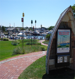
A public walkway connects downtown Hyannis, Massachusetts, with the waterfront. Courtesy: Town of Barnstable
Barnstable, Massachusetts
Located on Cape Cod, the town of Barnstable has been experiencing tremendous growth. In particular, Hyannis, one of the town's seven villages, was seeing low-density growth at its edges while its downtown emptied. This pattern strained the town's infrastructure and diminished its historic character.
In response, Hyannis developed a strategy that encourages growth in the urban center, which is served by existing sewer and water lines. The strategy includes mixed-use zoning and design guidelines, expedited permitting for downtown development, incentives to shift development from outlying areas to downtown, and improved connections to the waterfront. The town also purchased land to protect drinking-water aquifers and other important natural areas.
The result is a renaissance for Hyannis's downtown. As of 2007, 93 new residential units and 22,000 square feet of commercial space had been created since the initiative began, along with approximately 342 new jobs and $25 million in private investment. Improvements continue, including construction of a harbor-front visitor's center and additional segments for the town's planned harbor walk.
ELEMENT 3:
Provide a range of housing opportunities and choices to meet the needs of both seasonal and permanent residents
Santa Cruz, California
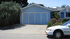
The Accessory Dwelling Unit (ADU) Development program in Santa Cruz, California, allowed for the conversion of a garage into an apartment. Courtesy: City of Santa Cruz
Like many communities in northern California, Santa Cruz has seen its housing costs increase dramatically, in part because of its coastal location on Monterey Bay and its desirability as a vacation, retirement, and second-home destination. In response to concerns over how to retain teachers, police officers, and service workers, the city created an Accessory Dwelling Unit (ADU) Development Program. The program makes it easier for homeowners to build a new structure or to convert all or part of a garage into an ADU. The city revised its zoning ordinance, commissioned design guidelines, and produced architect-generated building prototypes that have been pre-reviewed by city departments, thereby reducing processing time, planning fees, and design costs. To encourage affordable housing, loan and fee waiver programs are available to homeowners who will rent the unit at an affordable level. The program has been successful. In 2003, the program's first full year, 35 accessory units were built-a fourfold increase over the eight units built in 2001. Between 40 and 50 new accessory unit building permits have been issued each year since the program began.
ELEMENT 4:
Create walkable communities with physical and visual access to and along the waterfront for public use
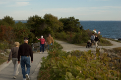
The Marginal Way is a public walkway along the Atlantic shore, located a block from Ogunquit's downtown. Courtesy: Enji Park
Ogunquit, Maine
In Ogunquit, Maine, the Marginal Way is a public walkway along the Atlantic shore, located a block from Ogunquit's downtown. The Marginal Way is a remnant of a pre-colonial coastal trail, which a coastal property owner donated to the town in the 1920s. The town, working with several contiguous property owners, acquired easements in the 1940s to extend the trail another 2,000 feet. Signs direct pedestrians from downtown to the entrance of the Marginal Way, which extends along the coastline for nearly two miles, including access paths, ending at Perkins Cove, a small working harbor near Ogonquit with a variety of shops and restaurants. The town holds full title to most of the land area of the trail and is responsible for its management and maintenance. For an Ogonquit resident or tourist, the Marginal Way complements an already walkable community. The vibrant, mixed-use downtown has wide sidewalks and shade trees, and visitors are encouraged to park in a municipal lot next to the downtown and explore the area on foot or via the Ogunquit Trolley, which provides service along the coast during the summer months.
ELEMENT 5:
Foster distinctive, attractive communities with a strong sense of place that capitalizes on the waterfront's heritage
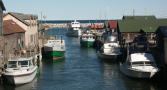
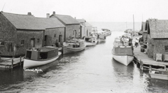
Revitalization of the Fishtown docks helped Leland, Michigan, capitalize on its heritage and history despite the decline of its traditional fisheries based economy. Courtesy: Rick Lahmann (above) and Leeland Historical Society (below)
Leland, Michigan
Leland, Michigan, turned the challenge of a declining commercial fishery into an economic opportunity by focusing revitalization efforts on its historic and natural resources fronting the Leland River and Lake Michigan. Leland identified the fishing complex known as "Fishtown," with its weathered fishing shanties, smokehouses, and docks, as a key element to preserve in maintaining the city's maritime heritage. Listed on the National Register of Historic Places, the preserved and renovated structures of Fishtown now provide visitors with an opportunity to learn about the Great Lakes' maritime tradition and enjoy recreational activities on Lake Michigan and Lake Leelanau. Fishtown has helped Leland, with its walkable downtown and easy access to the water, capitalize on its heritage and history despite the decline of its traditional fisheries-based economy.
ELEMENT 6:
Preserve open space, farmland, natural beauty, and the critical environmental areas that characterize and support coastal and waterfront communities
Acquiring and protecting land along Brays Bayou in Houston, Texas, has helped provide community open space, protect water quality, reduce the potential for flood damage, and enhance wildlife habitat. Courtesy: Harris County Flood Control District
Brays Bayou, Houston, Texas
The National Oceanic and Atmospheric Administration's (NOAA) Coastal and Estuarine Land Conservation Program (CELCP) was established in 2002 to protect valuable coastal and estuarine lands. One of CELCP's projects is in Brays Bayou in Houston, Texas. Through direct acquisition, CELCP grant funds are helping to protect about five acres of undeveloped floodplains along the bayou in a mixed-use neighborhood in East Houston. The city of Houston initiated this project in an effort to set aside land for public open space, restore and maintain water quality, reduce the potential for flood damage, and enhance wildlife habitat along the bayou. Although CELCP funds are buying only a small number of acres, these lands will complement previously acquired parcels and be combined with several planned acquisitions along the stream corridor. By improving access to the bayou, including walking and biking trails as well as scenic, shaded spaces for picnics, this project protects open space to reconnect a historically underserved urban community with the water. Restoration efforts undertaken by local volunteers and school groups are not only restoring marshland vegetation and wildlife habitat, but are also teaching the participants about the value of functioning wetlands. By keeping the land undeveloped and permeable to capture runoff from storms, this project will help reduce the potential for flood damage in an area that, since its early history, has had significant flooding problems. The project is also providing important wildlife habitat and a welcome community amenity that will strengthen residents' connection to the bayou.
ELEMENT 7:
Strengthen and direct development toward existing communities and encourage waterfront revitalization
Providence, Rhode Island's Downcity Providence and Waterplace Park
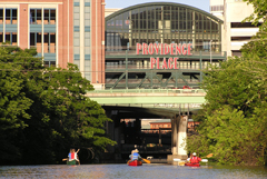
Revitalization of Downcity, including developing Waterplace Park and Riverwalk to provide pedestrian, canoe, and kayak access to the Providence River, has signaled the rebirth of downtown Providence, RI. Courtesy: Pam Rubinoff, RI Sea Grant
For much of the past two centuries, the downtown and Old Harbor of Providence, Rhode Island, functioned as the city's industrial and commercial center. Now often referred to as "Downcity," the area declined beginning in the 1950s, leading to the departure of water-related industries and the eventual burial of the Providence River for urban renewal purposes. In the early 1990s, when many of the Downcity buildings were vacant or underused, Providence developed a revitalization strategy to create a "round-the-clock" neighborhood and destination in the core of the city and along the Providence River.
The Downcity Master Plan and Implementation Plan called for the city to focus arts and entertainment uses in the downtown; create personal tax exemptions for artists, writers, painters, and composers to move to the area; and implement tax incentives for developers to create apartments and lofts in underused properties. Providence also reformed its zoning code to allow residential uses in commercial buildings. In combination with tax credits for restoring historic buildings, this led to the rehabilitation and reuse of many historic structures. Downcity is now connected with Waterplace Park and the Riverwalk, public spaces on the river that draw hundreds of thousands of visitors annually. These places were made possible in part by uncovering the Providence River, which once again flows through the city and is the focal point for Waterplace Park and the Capital Center area.
Downcity and the area made up of Waterplace Park, Riverwalk, and the Capital Center have seen more than $200 million in private investment, including over 40 new ground-level retail, entertainment, and restaurant establishments. While the nature of waterfront activities has changed, the area is again a thriving downtown with a variety of entertainment, shopping, cultural, and living opportunities.
ELEMENT 8:
Provide a variety of land- and water-based transportation options
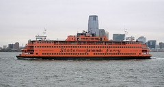
The Staten Island Ferry provides a water-based transportation option for 65,000 passengers daily, reducing congestion in the bridges and tunnels that provide access to Manhattan and reducing associated pollution. Courtesy: Mike Powell / CC BY-SA 2.0
The Staten Island Ferry, New York
Every year, the Staten Island Ferry gives more than 19 million passengers-including commuters, residents, and tourists-a ride across New York Harbor between Staten Island and lower Manhattan. The ferry runs 24 hours a day, every day of the year. Operated by New York City as a municipal service since 1905, the ferry serves 65,000 passengers on a typical weekday and is open to pedestrians only. Rail and bus service is available at both ferry terminals; the Staten Island Terminal is served by multiple buses and the Staten Island Railway, while the Whitehall Terminal in Manhattan is within walking distance of the city subway and three bus lines. According to New York City's Independent Budget Office, about 40,000 weekday trips are made on the ferry by Staten Island residents, equivalent to roughly 20,000 two-way commuter trips a day across the two bridge and tunnel routes into lower Manhattan. Given that a typical bridge or tunnel lane can accommodate about 6,000 vehicles during peak rush hours, the ferry has helped to reduce congestion, as well as the need for investment in additional lane capacity.
ELEMENT 9:
Make development decisions predictable, fair, and cost-effective through consistent policies and coordinated permitting processes
Bremerton, Washington
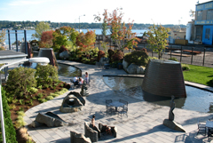
Bremerton, Washington, invested in a waterfront park and streamlined the development process along shoreline of Puget Sound to attract residential and commercial development. Courtesy: Matt Dalbey, USEPA
The city of Bremerton, Washington, recognized that the revitalization of its waterfront along Puget Sound and its downtown next to the waterfront were central to the community's future. Revitalization of the waterfront was particularly challenging, since the area included the U.S. Navy's Bangor shipyard and submarine base and the state-controlled Seattle-Bremerton Ferry terminal. Vacant and underused sites that were ideal places for new development were subject to a myriad of development regulations, as well as Homeland Security regulations (given the proximity to the shipyard and submarine base).
To address these challenges, Bremerton implemented a Shoreline Master Program, a waterfront redevelopment policy tool available to localities through Washington's Shoreline Management Act and the Bremerton Community Renewal program, and set out to create a redevelopment climate that would attract private developers to build projects the city needed and the market could support. Public investments in the ferry terminal, a conference center, and a waterfront park attracted private developers who invested in office and residential properties. Since 2000, over $500 million worth of construction has occurred in the Harborside District. Bremerton has capitalized on this success by adopting a new downtown plan, complete with design guidelines, mixed-use zoning, and streetscape standards, that has streamlined the development process.
ELEMENT 10:
Encourage community and stakeholder collaboration in development decisions, ensuring that public interests in and rights of access to the waterfront and coastal waters are upheld
Vienna, Maryland, used community workshops, surveys and interviews to create a development plan that articulates the community's vision for both accommodating growth and preserving its rural character in the future. Courtesy: The Conservation Fund
Vienna, Maryland
Vienna is a small town on the Nanticoke River, a tributary of the Chesapeake Bay. One of the oldest settlements in Maryland, with an original plan dating back to 1706, this town on Maryland's Eastern Shore retains a strong fishing and agricultural base. In response to growth pressures in the early 2000's and to prepare for a scheduled update of the town's comprehensive plan, Vienna asked The Conservation Fund, a national nonprofit group, to help develop a new vision for the community. The town council, the mayor, and experts from The Conservation Fund worked with the community to assess the town's natural resources, economic opportunities, land use trends, and development potential. The tools they used included a public opinion survey that involved about half the town's adult population, in-depth community interviews with individual residents, and community workshops. As a result, the town developed a plan that preserves Vienna's rural town character while still accommodating growth. Although the nationwide real estate downturn of 2008 gave the area some breathing room, residents and real estate experts expect development to return. When it does, the Vienna-Conservation Fund process can serve as a model for conservation and growth in the Chesapeake Bay watershed.
Additional Case Studies
Coastal Smart Growth Elements in Practice - Case Studies from the Great Lakes Region: were selected using 10 coastal and waterfront smart growth elements developed collaboratively by U.S. EPA and NOAA, largely building of the national smart growth elements but with a focus on the unique attributes of coastal areas and communities, such as waterfront revitalization, preserving, and enhancing coastal heritage, public engagement in the application of public trust doctrine, and public access to the water.- Ashland, Wisconsin (pdf)
- Oswego, New York (pdf)
- Porter County, Indiana (pdf)
