
Coastal Smart Growth Home: Element9
ELEMENT 9:
Make development decisions predictable, fair, and cost-effective through consistent policies and coordinated permitting processes
Smart Growth Principle
In most communities across the country, the private sector is responsible for the overwhelming majority of new development. New development has many costs. Most of them-land, materials, and labor, for instance-can be accurately identified and accounted for by a developer. However, the costs for permitting, zoning variances, site reviews, and compliance with applicable regulations are often less clear and can be compounded by the time each process takes. Because compact, mixed-use projects diverge from conventional plans for single-use projects, they are more likely to need extra reviews in communities that do not have smart growth-supportive zoning codes. For development projects to succeed, they must be buildable within a reasonable timeframe, with a likely profit commensurate with their risk. The public sector can support environmentally responsible development by reducing barriers to smart growth, ensuring that the development process for all projects is efficient, fair, and transparent.
Coastal and Waterfront Context
In waterfront and coastal communities, strong and often competing demands between development, recreational uses, and protection of the environment must be balanced. The uncertainty in development can be magnified by the extra layers of local, state, and federal regulations that apply along the water. Often, planning and permitting agencies have different roles and responsibilities that must be reconciled. By creating an easily understood, predictable development process, waterfront and coastal communities can create a climate that is more likely to produce projects that meet multiple community goals. This can be achieved by effectively coordinating across regulatory agencies, providing non-regulatory incentives, and allowing flexibility in local development policies.
Tools & Techniques
In any community, a first step toward greater fairness and predictability is to establish a vision for growth. Visioning is often accomplished through charrettes and other stakeholder involvement processes (see Element 10 for more detail on these processes). Some communities have followed up on visioning processes with "policy audit" tools that help identify inconsistencies between their established vision for growth and existing policies, codes, and regulations. Others have directly approached developers, public officials, and interested citizens to simply ask what they each believe are the barriers to better development. Whatever the method used, once these obstacles are identified, communities can work with the appropriate regulatory agencies to adopt a policy framework that makes it easier for developers to implement the community's vision.
Such a policy framework may include centralized, easily accessible information for the planning, review, and permitting processes, making them more transparent and helping to hold responsible regulatory agencies accountable. For example, Louisiana's on-line Coastal Use Permit system allows applicants to file an application and revisions, track the application's progress through the entire permit process, and receive expedited authorizations. Readily available information like this on the status of pending applications makes the process more predictable. Other jurisdictions coordinate the review and approval of plans and permits. Florida, for example, consolidates applications for coastal construction permits, environmental resource permits, wetland resource (dredge and fill) permits, and submerged lands authorizations for a single project into a "joint coastal permit" issued by a single agency. This system minimizes potential conflicts among permitting agencies and helps ensure efficient reviews.
A tool specifically applicable to the coastal development process is the Special Area Management Plan (SAMP). Created by the Coastal Zone Management Act, these plans provide a formal mechanism for cross-jurisdictional coordination of land-use policies in coastal areas. The Rhode Island Metro Bay Region SAMP, which encompasses 24 miles of shoreline at the head of Narragansett Bay, was developed by the Rhode Island Coastal Resources Management Council in collaboration with the four metropolitan communities of Cranston, East Providence, Providence, and Pawtucket. Covering most of the waterfront in these four cities, the Metro Bay Region SAMP was developed to improve the working waterfront, provide public access to the water and along the shoreline, and attract new development with a more predictable and efficient permitting process. Rhode Island state agencies and municipalities are required by state law to hold joint permit review meetings for large-scale projects. The SAMP process ensures a coordinated review of coastal projects and facilitates a more effective and efficient local and state permitting process.
Design guidelines can also help streamline the process. Communities can create guidelines that show developers and builders the form of buildings, streetscapes, setbacks, and elevations that are compatible with local codes and ordinances. Guidelines can include specific provisions reflecting the community's distinctive natural setting and heritage. The city of Norfolk, Virginia, on the James River and Chesapeake Bay, commissioned a pattern book that identifies various styles found in different neighborhoods and illustrates architectural components, such as the design of windows, doors, and porches, that have the development character the community wants. This gives developers a clear guide to what designs are acceptable.
In coastal and waterfront communities, the complex local, state, and federal regulatory framework may make it more challenging to create a predictable development climate. However, these communities have access to a wide variety of tools to make it easier for the private sector to build projects that meet multiple community goals.
| Key Action Options | Policies, Tools, and Techniques for Implementation |
|---|---|
Come to consensus on a vision for future growth
|
|
Develop processes that make decisions predictable and faster while meeting community development objectives and protecting natural and cultural resources |
|
Make development processes transparent, fair, and inclusive |
|
Provide centralized, easily accessible information |
|
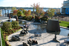
Bremerton, Washington, invested in a waterfront park and streamlined the development process along shoreline of Puget Sound to attract residential and commercial development. Courtesy: Matt Dalbey, USEPA
Case Study: Bremerton, Washington
The city of Bremerton, Washington, recognized that the revitalization of its waterfront along Puget Sound and its downtown next to the waterfront were central to the community's future. Revitalization of the waterfront was particularly challenging, since the area included the U.S. Navy's Bangor shipyard and submarine base and the state-controlled Seattle-Bremerton Ferry terminal. Vacant and underused sites that were ideal places for new development were subject to a myriad of development regulations, as well as Homeland Security regulations (given the proximity to the shipyard and submarine base).
To address these challenges, Bremerton implemented a Shoreline Master Program, a waterfront redevelopment policy tool available to localities through Washington's Shoreline Management Act and the Bremerton Community Renewal program, and set out to create a redevelopment climate that would attract private developers to build projects the city needed and the market could support. Public investments in the ferry terminal, a conference center, and a waterfront park attracted private developers who invested in office and residential properties. Since 2000, over $500 million worth of construction has occurred in the Harborside District. Bremerton has capitalized on this success by adopting a new downtown plan, complete with design guidelines, mixed-use zoning, and streetscape standards, that has streamlined the development process.