
Coastal Smart Growth Home: Element 4
ELEMENT 4:
Create walkable communities with physical and visual access to and along the waterfront for public use
Smart Growth Principle
In a walkable community, trips by bicycle or on foot are viable transportation alternatives to the car. Walkable communities locate a mix of uses, such as homes, shops, and schools, close to each other. They provide sidewalks, crosswalks, and bike lanes that create safe passage for walkers and bikers, and they offer convenient, well-designed parking that encourages people to park and walk to their destination. Walkable communities offer more transportation choices, higher levels of social interaction, greater opportunities for physical activity, and reduced emissions from automobile travel.
Coastal and Waterfront Context
For waterfront communities, improving the connection between pedestrians and the water can increase interest in walking and biking and help to decrease the pressures of seasonal traffic. The pedestrian connection to the water can be improved physically, with better street, path, and trail connections, and with access points to the water that are open to the public. The connection also can be approached visually, by designing the built environment in ways that preserve the view of the water and encourage residents and visitors to access the waterfront on foot. Orienting the built environment to the water can improve public access to it and encourage a better appreciation of this precious asset.
Tools & Techniques
Ensuring physical access from streets or sidewalks to the waterfront can be a challenge, however. Many coastal and waterfront communities have a shortage of public-access facilities, such as public walkways and boat launches. In some communities, traditional public access sites have been converted to private uses. It can be difficult to acquire new access points because of the prohibitive costs of both land and maintenance. The public also may be unsure of how to access the water if adequate signage is not provided. Additional challenges arise when people headed to the water to swim, stroll, fish, or surf inadvertently degrade sensitive natural areas near the water. Pedestrian access to the water must not only be connected to the built environment, but also accommodated in ways that protect natural resources.
A number of tools can help. Communities can inventory where the public access points are, flag the gaps, and put all this information on a map. Then, with maps and inventories at hand, visioning exercises can help residents and visitors articulate how they expect to access the water and what they expect to do there. In Grand Marais, Minnesota, the city used a community visioning process to define redevelopment options for a derelict gas station located between the waterfront and downtown. The community decided to create a waterfront park on the site. Today, Harbor Park better connects downtown Grand Marais to its waterfront; visitors and residents walking its paths enjoy unobstructed views of and access to Lake Superior. The park has become a community centerpiece, regularly hosting festivals and other community gatherings.
Once a vision is developed, it should be incorporated into pedestrian master plans, mixed-use zoning, and capital improvement plans that codify and fund improved access. Localities then can provide incentives or adopt regulations guiding plans for water access in future development. Along the Amelia River waterfront area of Fernandina Beach, Florida, the city established a "floating" overlay district that allows property owners to double their density if they grant the city an easement to build a public boardwalk along the riverfront, allow pedestrian access, and maintain a view corridor. The overlay district also promotes a mix of uses by requiring housing to be located above ground-floor commercial or office uses.
Efforts to ensure access are complemented by tools that can make communities safer and more appealing for pedestrians. A "park once" strategy encourages development of centrally located parking (preferably away from the water) that allows workers and visitors to leave their cars and walk to their destinations. Proper "wayfinding" planning can encourage more activity on foot or bike by providing maps, good signage, and other guidance directing people to the waterfront and other amenities. Additionally, placing a public dock near a walkable waterfront makes it easy for visitors arriving by water, via a public ferry or private vessel, to access the community by foot (see Element 8 for additional information on water-based transportation). Sidewalk design standards that provide ample room for walking (buffered from traffic by parked cars or trees and other vegetation) can encourage more pedestrian activity. Trees, planting strips, and rain gardens create more pleasant pedestrian environments and can be designed to manage stormwater runoff. Finally, routine evaluations of permits, zoning laws, street design guidelines, and other policies can help ensure that existing regulations and programs enhance the walking environment and support the community's desire to design and position buildings in ways that make the water easy to access.
A walkable community requires much more than a sidewalk, path, or boardwalk. In coastal and waterfront communities, it calls for a comprehensive approach to building and street design, parking, zoning, and water access that ensures that pedestrians are safe, welcome, and have a range of destinations-water- and land-based-to which they can walk.
| Key Action Options | Policies, Tools, and Techniques for Implementation |
|---|---|
Mix land uses and design buildings to foster pedestrian activity and visual access to water |
|
Foster a safe and supportive infrastructure for walking, biking, and other non-motorized means of travel |
|
Expand and manage physical access to the water |
|
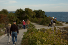
The Marginal Way is a public walkway along the Atlantic shore, located a block from Ogunquit's downtown. Courtesy: Enji Park
Case Study: Ogunquit, Maine
In Ogunquit, Maine, the Marginal Way is a public walkway along the Atlantic shore, located a block from Ogunquit's downtown. The Marginal Way is a remnant of a pre-colonial coastal trail, which a coastal property owner donated to the town in the 1920s. The town, working with several contiguous property owners, acquired easements in the 1940s to extend the trail another 2,000 feet. Signs direct pedestrians from downtown to the entrance of the Marginal Way, which extends along the coastline for nearly two miles, including access paths, ending at Perkins Cove, a small working harbor near Ogonquit with a variety of shops and restaurants. The town holds full title to most of the land area of the trail and is responsible for its management and maintenance. For an Ogonquit resident or tourist, the Marginal Way complements an already walkable community. The vibrant, mixed-use downtown has wide sidewalks and shade trees, and visitors are encouraged to park in a municipal lot next to the downtown and explore the area on foot or via the Ogunquit Trolley, which provides service along the coast during the summer months.
