
Coastal Smart Growth Home: Element 7
ELEMENT 7:
Strengthen and direct development toward existing communities and encourage waterfront revitalization.
Smart Growth Principle
Infill development in existing communities, where roads, utilities, and transportation connections are already in place, is a preferred growth strategy because of the many environmental and economic benefits it provides. When communities convert underused infill sites, such as parking lots or vacant properties, into vibrant mixed-use developments, they strengthen their local tax base, concentrate growth, and reduce pressure to convert undeveloped land, yielding significant air and water quality benefits. Redevelopment of brownfields-sites where reuse is complicated by real or perceived contamination-removes environmental hazards from communities and provides new investment opportunities in areas already well served by infrastructure. New development and investment in these infill locations can re-energize lagging commercial corridors, providing new stimulus to preserve traditional uses and promote recreational opportunities that strengthen the local economy.
Coastal and Waterfront Context
In many coastal and waterfront areas, properties at the water's edge are prime redevelopment targets, since they are in or near the historic center of the community, are well connected to land- and water-based modes of transportation, and are close to jobs, services, and tourist sites. Waterfront revitalization can enhance historic, cultural, and scenic resources, supporting community efforts to maintain a strong sense of place while protecting the water and other natural resources.
However, redevelopment of waterfront properties can pose challenges as well as opportunities. Historic buildings are distinctive, potentially profitable opportunities for reuse. But to encourage their renovation, communities may have to adopt "rehab" codes to offset the unintended barriers to redevelopment that standard building codes for new construction may contain. Brownfield revitalization efforts along the water also may be complicated because of the presence of protected, threatened, and endangered species and the possibility of contaminant runoff. Furthermore, the redevelopment of buildings to support non-water-dependent uses in areas traditionally dominated by water-dependent uses can result in displacement and gentrification (see Element 1 for further discussion of mixing uses). Finally, all coastal and waterfront communities need to consider their vulnerability to natural hazards such as storms and flooding, and, for those on the coast, the risks from sea level rise, so that revitalizing the waterfront does not make the community more vulnerable to natural disasters.
Tools & Techniques
Nevertheless, infill and redevelopment efforts at the water's edge offer great potential for underscoring the connections between a community's culture, built environment, and natural resources. Through a robust planning process, stakeholders representing varied interests and organizations can unite in the common goal of revitalizing the waterfront in ways that protect the built and natural environments. For example, the city of Glen Cove, New York, located on Long Island Sound, used a community-based waterfront revitalization planning process to transform 214 acres of brownfields to mixed-use development along the north shore of Long Island. The city brought together federal, state, and local partners to leverage support for its waterfront revitalization. The city then developed and implemented the Glen Cove Creek Waterfront Revitalization Plan in partnership with NOAA and the New York State Coastal Management Program. The plan and resulting zoning changes provided a road map for the community's vision and was a basis for building stakeholder support and developing partnerships for implementation. Because of this work, Glen Cove has leveraged over $40 million from public and private sources to support its waterfront revitalization initiative.
In addition to creating rehab codes and pursuing brownfields redevelopment, communities can use other tools to target development to strengthen existing areas. Historic preservation districts, tax benefits, and incentives can support retrofitting the historic waterfront for new uses while protecting important structures and facades. Also, state or local "fix it first" policies can give priority for scarce public infrastructure investment dollars to existing communities, rather than expand services to undeveloped areas. States such as Massachusetts, New Jersey, and Maryland-all of which have many waterfront communities-have implemented "fix it first" policies to attend to the needs of existing communities. In addition, concurrency policies can ensure that new development supports itself-in the form of roads, utilities, and schools needed to support new growth-thereby conserving public resources for repair and upgrading in already developed areas.
Communities must carefully consider the economic and environmental context before determining the best location for growth, development, and redevelopment. Along the water, this has always included factors such as sensitive natural areas, storms, and flooding. Communities facing the possibility of increased vulnerability from climate change-related impacts, such as increased flooding and sea level rise, may need to consider whether infill or redevelopment is appropriate. In appropriate locations, these development strategies can yield important economic, environmental, and community benefits.
| Key Action Options | Policies, Tools, and Techniques for Implementation |
|---|---|
Promote community-based waterfront revitalization efforts
|
|
Promote infill development by preserving, upgrading, and reusing existing properties |
|
Retrofit historic waterfront for new uses |
|
Clean up and reuse brownfields |
|
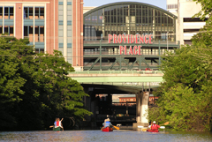
Revitalization of Downcity, including developing Waterplace Park and Riverwalk to provide pedestrian, canoe, and kayak access to the Providence River, has signaled the rebirth of downtown Providence, RI. Courtesy: Pam Rubinoff, RI Sea Grant
Case Study: Providence, Rhode Island's Downcity Providence and Waterplace Park
For much of the past two centuries, the downtown and Old Harbor of Providence, Rhode Island, functioned as the city's industrial and commercial center. Now often referred to as "Downcity," the area declined beginning in the 1950s, leading to the departure of water-related industries and the eventual burial of the Providence River for urban renewal purposes. In the early 1990s, when many of the Downcity buildings were vacant or underused, Providence developed a revitalization strategy to create a "round-the-clock" neighborhood and destination in the core of the city and along the Providence River.
The Downcity Master Plan and Implementation Plan called for the city to focus arts and entertainment uses in the downtown; create personal tax exemptions for artists, writers, painters, and composers to move to the area; and implement tax incentives for developers to create apartments and lofts in underused properties. Providence also reformed its zoning code to allow residential uses in commercial buildings. In combination with tax credits for restoring historic buildings, this led to the rehabilitation and reuse of many historic structures. Downcity is now connected with Waterplace Park and the Riverwalk, public spaces on the river that draw hundreds of thousands of visitors annually. These places were made possible in part by uncovering the Providence River, which once again flows through the city and is the focal point for Waterplace Park and the Capital Center area.
Downcity and the area made up of Waterplace Park, Riverwalk, and the Capital Center have seen more than $200 million in private investment, including over 40 new ground-level retail, entertainment, and restaurant establishments. While the nature of waterfront activities has changed, the area is again a thriving downtown with a variety of entertainment, shopping, cultural, and living opportunities.
